(Bihar Times) A technocracy that is caught in time warp has clearly failed in its misplaced attempt to tame the river by not acknowledging that Kosi is most violent and unstable river of the world. Over the last 250 years, the Kosi River has shifted its course over 160 kilometres from east to west. Continued and sustained support for a totalitarian science of embankments has failed, not once or twice but eight times till date. If there is anything to learn from the failure in taming of Rhine and Meuse rivers, it is adopting 'room for the river' approach.
A high-level Government of Nepal has held India responsible for the havoc. Indo-Nepal Kosi treaty of 1954 makes India responsible for repair and maintenance work and operation of the barrage. International rivers merit special treatment but a look at the current situation illustrates how fossilized institutions of South Asian hydrocracy in general and Indian hydrocracy in particular have missed the river for the dam.
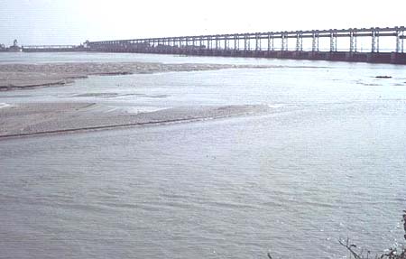
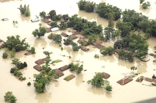
The Kosi embankment was breached almost predictably near the Kusaha village in Nepal on August 18, 2008 turning four Panchayats of Nepal: Western Kusaha, Sripur, Haripur and Laukahi with a population of nearly 35,000 in to a watery graveyard. The flood-affected districts in Bihar include Supaul, Saharsa, Araria, Purnea, Katihar, Madhepura, Khagaria and parts of Bhagalpur. Following the breach, the water is flowing through three of the some 15 old streams of the Kosi river, namely Sursar, Mirchaiya and Belhi.
Approximately 85 per cent of some 1.5 lakh cubic feet per second (cusecs) of Kosi water is flowing through the breach in the embankment. Initially, the breach was quite small-just few metres-wide- on the eastern side, 12.9 km upstream of the Bhimnagar barrage in the afternoon of August 18 now it has widened to more than two km now, destroying standing crops and flattening houses coming on its way. It is noteworthy that the embankment and the barrage were designed to resist 9.5 lakh cusecs of water flow but it could not resist the flow of water, which was about 1.44 lakh cusecs. Given the fact that the river is embanked at least 135 km downstream from the site of the breach, the water flow was compelled to go into the old Kosi streams.
The immediate sequence of events is quite revealing. State chief state engineer E Satyanarayan, stationed at Birpur near the Nepalese border where the Kosi river breached its embankments in August, 2008 had sent officials like Arun Kumar, responsible for Kosi project four desperate warnings between August 9 and 16, cautioning them against the imminent disaster, which went unanswered because the officer in question was on leave and no substitute for him was made available for decision making. Eventually on August 16, with the situation worsening, the desperate engineer sent telegrams to 11 senior officials associated with flood water management in the state capital Patna. These were also ignored by callous IAS officers of the state. Two days later the Kosi flowed southward breached the embankment at the point Satyanarayan (now suspended) had identified as vulnerable.
In 1908 itself, Engineer Captain F C Hirst, in 1908, had predicted how flood control structures for temporary relief could become "a menace to future welfare". Books and reports on misplaced engineering interventions for flood control from 1962 to 2007 seeking performance evaluation of embankments and dams has not inspired any remedial action so far. It is unlikely to do so in any foreseeable future.
Who is accountable for this criminal lapse? It is the eighth breach since its construction Who all were liable for the criminal interventions of the past? There were no answers and there will be no answers. The Indian "development nation-state" is infertile, it cannot deliver any.
This development needs to be looked at in the light of recent deliberations in the parliament to comprehend the acts of omission and commission by both the central and Bihar government. Union Ministry of Water Resources misled the Rajya Sabha, (Upper House of Parliament) on March 11, 2008 on the issue of "Floods in North Bihar" that ensures a status quo of misery in the region. In a Press Information Bureau release, it claimed, "Government has taken various steps in the direction of water management to stop the flood in North Bihar coming from the rivers of Nepal. To control the floods in rivers Bagmati and Kamala-Balan in north Bihar, the Government has approved two schemes, namely, (i) Raising and Strengthening of Embankments along River Bagmati at an estimated cost of Rs.135.16 crore and (ii) Raising and Strengthening of Embankments along River Kamala at an estimated cost of Rs.52.09 crore."
What it means to raise and strengthen the embankments has come to light from the preliminary findings of the multidisciplinary 14 member Fact Finding Team that toured the flood affected regions of North Bihar from March 1-8, 2008 along the embanked parts of Kosi, Kamala, Bhutahi Balan and Baghmati rivers. The team noted, "The manner in which floods have been amazingly sustained in this region despite over five decades of relentless efforts."
The current proposals illustrates that the embankment lobby has gained momentum once again, the fact that such interventions will raise river levels by several meters, making the land between the embankments uninhabitable for millions of people displacing them for good. The bitter experience of flood control embankments has given birth to a strong sentiment against it.
Now it is a common knowledge and the narratives of the villagers corroborate that embankments are for the benefit of the contractor politicians and the technocratic development ideology to deal with flood suits them unmindful of the environmental and social mess. The statistics also show that 8.36 lakh hectare of land in North Bihar is permanently waterlogged, which is nearly 16 per cent of the North Bihar's total area, earning the state the dubious distinction of being the leading claimant of this kind of manmade submergence.
It concluded that "not only are these floods manmade but that the worse is yet to come should the political economy of flood control continue to pivot itself around `temporary embankment' as the only solution to the scourge of floods. The state pretends that it is afflicted by the colossal ignorance regarding the primary function of floodwater--draining out excess water and the fact that no embankment has yet been built or can be built in future that will not breach." The team found, "The government's investment of over Rs 1600 crores since the early 1950's has helped increase the flood prone area from 25 lakh hectare during the pre-plan era to over 68.8 lakh hectare today, an unprecedented three-fold increase. Proposed as temporary measure to control floods in the 1950s and having had failed on all fronts, the team is bewildered to note that the business of embankment construction has resumed after a lapse of 17 years with a Rs 792 crores package to tame the Bagmati. There is another proposal to embank the tributaries of Mahananda at an estimated cost of Rs 850 crores. Clearly, the lessons in human misery have not been learnt."
The Ministry took the parliament for ride by stating "Government of India has initiated steps for creation of storages in the Nepal territory which will help in mitigating the problem of floods being faced in North Bihar." The fact is that the negotiation that has been going on since 1947 between India and Nepal on creation of storages remains inconclusive. It has been said time and again that the Government would negotiate with Nepal to construct a dam over Kosi river.
The Ministry claimed, "A Detailed Project Report for the Sapt-Kosi High Dam project and Sun Kosi diversion scheme is under preparation jointly with the cooperation of the Government of Nepal." The steps that are claimed to have been initiated, are as old 60 year old but they remain where they were in 1945. A joint Indo-Nepal team of experts has been engaged in a field study of the proposed Kosi High Dam, which was first mooted in 1947. The matter relating to construction of dam over Kosi river is an international matter. The construction of this dam is possible only when there would be an agreement between Nepal and India. The negotiation have bee going on for a long time but we could not reach at any agreement till now.
The Ministry informed the parliament that "The Central Government has envisaged to make a comprehensive assessment of the feasibility of linking the rivers in the country starting with the southern rivers in a fully consultative manner. It would also explore the feasibility of linking sub-basins of rivers within the States, like Bihar. Six intra-state link proposals have been identified in Bihar by the State Government of Bihar, namely, (i) Kohra-Chandravat,(ii)Burhi-
Gandak-None-Baya-Ganga,(iii)Bagmati-Burhi-Gandak through Belwabhar, (iv) Kosi-Ganga, (v) Kosi-Mechi (Indian portion) and (vi) Karmanasha-Suara links in Bihar. The State Government of Bihar has commenced the study of these Intra-State links." Interlinking of Rivers is suggested for flood proofing among other things. A 'Report of the Expert Committee' to study impact of interlinking of rivers on Bihar (April 2005, Chapter III, p16) says, "…But the proposed Sapta Kosi Dam too has not been provided with any flood cushion which should be provided for flood moderation…"
After compounding the misery of North Bihar and Nepal through embankments, those living today in the flood-affected region are being promised other ecologically disastrous projects like Barahkshethra Dam and Interlinking of Rivers is like proposing one catastrophe to solve another. The both central and Bihar water resources ministry is vying with each other to undertake these projects that tantamount to replumbing the planet.
No political party both within the state and at the center can be absolved of acts of omission and commission that has brought perennial misery to North Bihar and Nepal because their policy decisions have contributed to it. Having invented lame excuses umpteen times, the politicians and acolytes of all hues are now arguing that the river has changed its course and it now wants to move to east. In the absence of even an iota of accountability towards criminal neglect, the million dollar question posed by flood experts that remains unanswered is: why were the embankments constructed along the river? Weren't they supposed to prevent the river from moving either east or west? Did the Bihar's Water Resources Department know that the river wanted to change its course? Is Central Water Commission relevant
anymore? Why did it help the river accomplishing its objectives?
It is high time the Ministry of Water Resources learnt from its blunders in Kosi. Unlike what is being promoted by the government "the only solution is to do away with the embankments and allow the river to go ahead with its natural land-building process," says Dr Dinesh Kumar Mishra, author of TRAPPED! Between the Devil & Deep Waters: The Story of Bihar's Kosi River.
Embankments have breached, it is breaching and it would breach again. Law of unintended consequences is clearly at work.
------------------------------------
*
Convenor of WaterWatch Alliance.& was a member of the Fact Finding Team that visited flood affected parts of North Bihar & Nepal in March 2008.
![]()